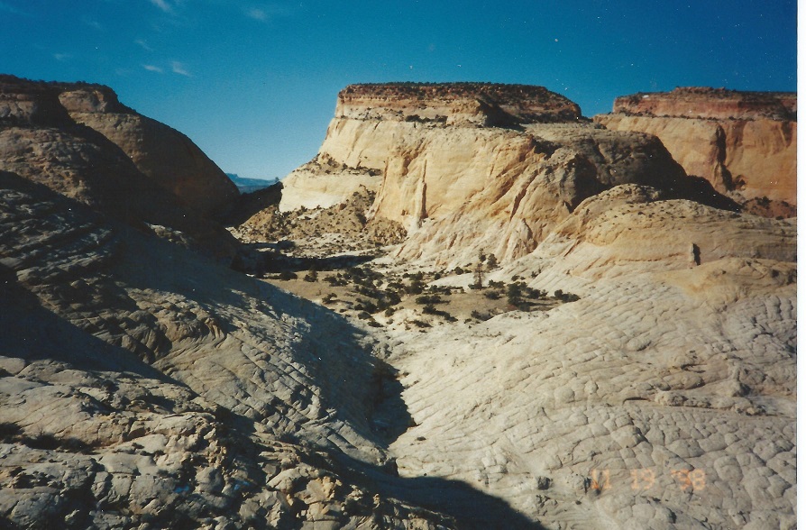
(Blowout Flat) and then continue west. At the high point on the west end of the flat you are standing beside Golden Throne and looking out over Miners Mountain to the west. (D)
A strenuous but beautiful hike through and above great Navajo Sandstone canyons. Due to private land restrictions getting to the proper canyon is a pain but it really is worthwhile.
The hike passes through a high basin which should be explored, high ridges can be climbed or run and the views are great. One option at the end of the hike is to walk completely around the base of Golden Throne.
| TIME: | 9-11 hours. |
| ELEVATION GAIN: | 1400 ft. |
| DIFFICULTY: | Moderate+ route finding. Moderate+ scrambling |
| MAP: | Golden Throne, Fruita |
| GEOLOGY: | Interesting Carmel and lots of the Navajo Formation. |
| CIRCLE TRIP: | A fabulous circle trip can be made by going up this canyon and back down Great Canyon. Great Canyon is the previous hike in this book. |
| ACCESS: | Unfortunately access is a problem for this, one of the nicest hikes in the Park.
The need to circumvent private land around Notom requires an unusual approach to the canyon. From the Visitor Center drive 9.2 miles east on Utah Highway 24 to the Notom Road. From that junction, drive south on the Notom road 1.5 miles to a two-track on the right. Turn right and follow the track 0.5 miles to an area where people occasionally camp. (A) If you do not have a 4-wheel drive vehicle, park here. If you drive on, bear right and drive into the wash. Drive up the wash about 0.1 miles to a "T" in the wash. Go left (south) and drive 1.1 miles to the (unmarked) Park boundary. Leave your vehicle there. (B) |
Up the wash beyond the above mentioned "T" there will eventually be some fence posts on the left side south of the wash. There is no wire left, just some old posts standing in line. The second time there are posts on the left (south) side you are close. The wash will head toward the line of posts then just before reaching them, make a hard turn to the right (west). Go around that bend and stop.
The fence posts come to a small cliff, then continue west below it. Just beyond the cliff a small wash enters the main wash from the south. Walk up the west side of that small wash, past a fence post, head south and continue staying low and east of the hill to the southwest. After passing the hill cross the largest wash between it and the next hill. Once across that wash bear right (southwest) and go up the ridge so that you pass north then west of the second hill.
From the west (right) side of that hill continue south and a bit west to pass west of the small ridge ahead. From west of that ridge continue south and walk down to the main wash ahead.
Three ridges will take you there but choose the center one so that you enter the main wash at the northern point of its visible path.
Once in the wash turn left (east) and walk downstream. The wash will head toward a low east-west trending ridge ahead on the right. There is a point on the end of that ridge. Follow the wash past (just below) that point. The main plant on that point is a Mormon Tea. Continue downstream another 200 feet past a brown vertical wash bank. There is another Mormon Tea plant on top of it. Just beyond that bank two tributary washes enter in quick succession from the south (right). Turn right (south) and walk up between the two washes. There is a steep ridge on the west and southwest horizon. As you walk up between those washes just to the right (west) of straight ahead there is an easily visible canyon mouth where a drainage breaks through that ridge. The temporary goal is to get to that canyon mouth. To avoid washes and hills, aim a bit left (south) of that canyon but stay west as far as comfortable while heading for that canyon. When you approach the wash coming out of that canyon, turn right (west) and go to within about 200 feet of the base of the main ridge. At that point; turn left (south).
Walk south parallel to the main ridge crossing three small washes to the next large wash. Cross that wash and immediately turn right (west). Depending on where you crossed the wash the climb to the top of the first ridge may be very steep or not so steep but which ever, go to the top of the ridge then follow it west. As you approach the end of the light gray rock on that ridge there may be a couple survey stakes, one on each side. Continue west through a small dip, then through a bit larger dip and on 150 feet up to the top of another ridge.
Stay high and walk generally west for 300 yards then turn left (south). If you soon come to a steep walled canyon turn right (west) and a pour-over will tame that canyon. Continue south to Calf Canyon. There will probably be a game trail to follow down into the wash of Calf Canyon (PN). Once there turn right (west) and head upstream. After ten minutes of walking in an open wash the canyon temporarily narrows and the thin, platy rock in the walls is a silty shale bed of the Carmel Formation.
Just beyond the narrow section the wash splits. Take the right fork (F) (straight ahead). Soon after the split the wash makes a sharp bend in an area that is usually wet. There are some nice cottonwood trees for shade, should you be looking to cool down. The flowing water in this part of the canyon is not recommend for drinking. It is likely to produce stomach discomfort and diarrhea even if filtered.
Continuing on up the wash there is a big log spanning the canyon. Walk under it and check it out. On the south end of the log you will see why the tree died. Many years ago someone girdled it with an axe and intentionally killed the tree. Just above the log find some low, bright green leafed, red barked bushes. These are Manzanita bushes which are common in the Navajo Sandstone areas of the Park, but not in the Carmel.
At the next wash junction go right (northwest). Just beyond that junction on the right is a young healthy Ponderosa Pine tree. Just around the corner there is a big, tall dead ponderosa that also was girdled. Up the wash, a short distance above the tree, there is a band of red rock not far up the canyon wall. That red layer is a distinctive layer of the Carmel Formation and is just a few feet above the bottom of the formation. By the time that layer is head high, you are walking in the Navajo Sandstone; the layer you will be in for the rest of the hike. Gone are the colorful and twisted layers, but the rocks still are not all evenly flat bedded. Bedding in the Navajo is varied and at odd angles. A thick (or thin) layer of parallel lines will abruptly end, truncated by other beds going at a different angle. The Navajo Sandstone is a thick layer of sand dunes piled on top of each other, that have been turned into rock while maintaining their original structure.
Twenty minutes into the Navajo Sandstone climb easily up a little narrow chute. One hundred yards farther up there is a wash junction. Pass a large Ponderosa Pine on the right during that 100 yards. For a canyoneering challenge go straight (right) at the junction. Most will prefer to go left (south) and climb up to the first bench layer above you. The bushes you will walk through at the wash junction are Little Leaf Mountain Mahogany displaying tiny needle shaped leaves, reddish barked Service Berry and Single Leaf Ash, a short tree.
Once on top of the bench, turn right (west) and continue up canyon above the wash. Notice where the slot that you avoided tops out. Go into the wash near that and head on up the canyon. In the wash, head toward the solid wall with a 100 foot pour-over. A short distance before you get to the wall there is a side canyon on the right (north) that will work for people with a good apatite for exposure. The best route, however, is to go up to the wall, pat it, (G) and then turn right (north). On one (of many) hikes up this canyon there was a large pool blocking access to the base of the wall. Once above the 100 foot pour-over do not immediately go back to the drainage unless you are looking for water. For water, go into the drainage where you will find a number of pot holes. To continue the trip, stay left (north) of the drainage and climb past a couple of ponderosa trees until you are at the level of a broad basin like area in the canyon. Return to the wash there and again choose your route or digress. The easier route from here takes you right up the south side of the basin by going up the shrub lined chute to the base of the upper cliffs. The chute is behind and above the dead topped ponderosa.
Digression: The basin is worth exploring and enjoying. About half way through the basin on the south side is a high pour-over that ends in a great pool behind a tall young ponderosa tree. (Do not swim. That is human and animal drinking water.) The most adventuresome and skilled may want to go to the head of the basin, turn left (south) and climb that route to the next level.
Back to the recommended route: climb the shrub lined chute to the base of the cliff island on top. Turn right (west) and traverse along the base of the cliffs. At the end of the cliff, you are on an open highland ridge. Follow that ridge and keep heading up stream above canyon that you have been following. The ridge will wind west and south, eventually driving you to a narrow area at the head of two canyons, one from the north (Calf Canyon) and one from the south.
Continue along the edge of Calf Canyon past the narrow area until you can see a slickrock way down.
The slickrock is not smooth, rather it is divided by joints and is variously called elephant hide or alligator hide.
Drop into the upper basin
(Blowout Flat) and then continue west.
At the high point on the west end of the flat
you are standing beside Golden Throne and looking out over Miners Mountain to the west. (D)
Circle trip: A really nice circle trip can be made from the end of this hike. It involves going around to the next canyon north (Great Canyon) and down it.
To do so, walk north a bit and work down to the west where, about 100 feet down, there is a nice bench on which to walk north to the next major canyon. Go up the far left side of that canyon and once on top (E) reverse the directions of the Great Canyon hike.
 | ||
23June2017
|
Email: | |
