This is a great hike with spectacular scenery. The view to the east from the starting point, Tub Flat, is really impressive in the late afternoon. The high chopped Navajo Sandstone walls along the hike are breathtaking. It is particularly interesting to those who know Capitol Reef National Park well because it is typical Capitol Reef and yet amazingly different than any other part of the Park.
A local rancher, Guy Pace, explains the origin of the name Tub Flat. He says that they put a bunch of tubs of salt on the flats for the stock and someone started calling it "Tub Flat".
| TIME: | 6 Hours plus exploration time. |
| ELEVATION GAIN: | 2,000+ feet. |
| DIFFICULTY: | Moderate + route finding. Moderate walking. |
| MAP: | Flat Top |
| GEOLOGY: | The birth of the Waterpocket Fold. |
| PLANTS: | Like no other part of Capitol Reef. |
| CIRCLE TRIP: | No. |
| ACCESS: | From the visitor Center drive 29 miles west on Utah Highway 24 to the town of Lyman. As the road leaves Lyman it bends almost 90 degrees and heads west. A sign to Fremont is 1.6 miles beyond that turn. Go right (north) toward Fremont. At the first stop sign you intersect Utah Highway 72. Go straight and follow 72 north to mile 11.5. Turn right at the sign to Elkhorn Campground and follow the dirt road up for nine miles. At five miles go straight past the Polk Creek road. At Elk Horn junction, 7.7, turn left toward Deep Creek Lake. At an unsigned junction go left. At 9.0 miles go left to Tub Flat. |
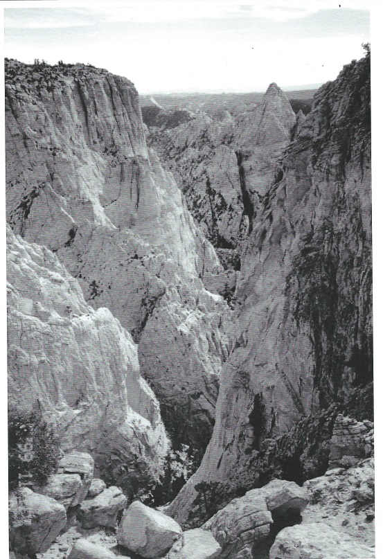
The view to the east from Tub Flat (T) is superb. Due to light angles the best views are in the afternoon and evening so consider camping at the Flat for a night before or after the hike.
From Tub Flat walk east staying on top of the bouldery ridge. Billings Point (One mile east along the ridge you are on) will soon come into view. That is the temporary goal. The walk down to Billings Pass is most easily done by winding somewhat around the groves of Aspen. The last drop to the Pass will require walking through one sparse grove. From Billings Pass go up to the east to Billings Point (B) - A 1952 survey point.
Digression: You have just walked the visual birthplace of the Waterpocket Fold. Structurally, the fold goes on west of Tub Flat, but it is not visible because subsequent lava flows that form the upper part of Thousand Lake Mountain have covered the fold. The visible fold goes east from Billings Pass then swings south and goes for a total of one hundred miles to just the other side of the Colorado River.
Digression 2. From Billings 9256 (Billings Point) there is a fairly gentle slope to the east for about 300 yards, then the slope steepens significantly and the vegetation closes in. That slope is NO place to hike. Almost immediately south of Billings Point there is a steep, loose, vegetated slope that is really unfun to walk. The following directions attempt to lead to the southeast trending ridge that is formed by the junction of these two slopes. That ridge is a breeze to walk as the game trail indicates.
From Billings Point walk east through a break in the trees. The tall shrubs or trees that form the sides of the break have clusters of small sturdy leaves an inch or less long. They are Curlleaf Mountain Mahogany. Walk east 100 yards to near the center of the open area then start to bear right (southeast) toward the edge of the opening (Toward the pass in the Henry Mountains.) An arm on the southeast side of that opening ends just as the slope steepens to the east. At or near the end of that arm take a narrow path (there is more than one) through the bushes (If there is a steep slope to the south, go farther east.) Find the trail descending just a few feet east of a ridge (C) that goes down to the Southeast.
Follow that trail (not always well traveled) staying within twenty feet of the ridge and often within only two or three feet. The trail will eventually take you to the top of a slope that is open to the south. Below you can see an open area and a great bench going along at the top of the cliffs that drop into Deep Creek. Go down and walk that bench. (D) It will first go south, then round a bend and head left (east).
As you are walking south along that bench notice the trees. Many of them are odd shaped pine trees. They are sort of droopy. Look closely and you will find they have short needles in clusters of five. These are Bristlecone Pines. The route following the bench or rim above Deep Creek will go through some nice groves of Bristlecones and they will be common for much of the hike.
Wander along above the Deep Creek cliffs always keeping them on the right (south). At one point the rim drops steeply, offering a nice view east at the upper canyons of both Deep Creek and Bullberry Canyon. The route may seem difficult to pick out but just keep the Deep Creek cliffs on the right (south).
Along, and at the base of that steep slope, the bright green shrubs (with red bark) are Manzanita. Gentle slopes at the bottom will eventually give way to steeper slopes again with great sheer canyon walls almost within reach. (Don't trip.) The rim will swing left and head northeast as it drops. At the bottom is a narrow saddle with a beautiful view to the south across Deep Creek.
The saddle floor is composed of black rock - a dike - that was intruded just 3-5 million years ago. The Waterpocket Fold is about 65 million years old. From the saddle, climb the slope and continue to follow the rim as far as you choose.
 | ||
23June2017
|
Email: | |
