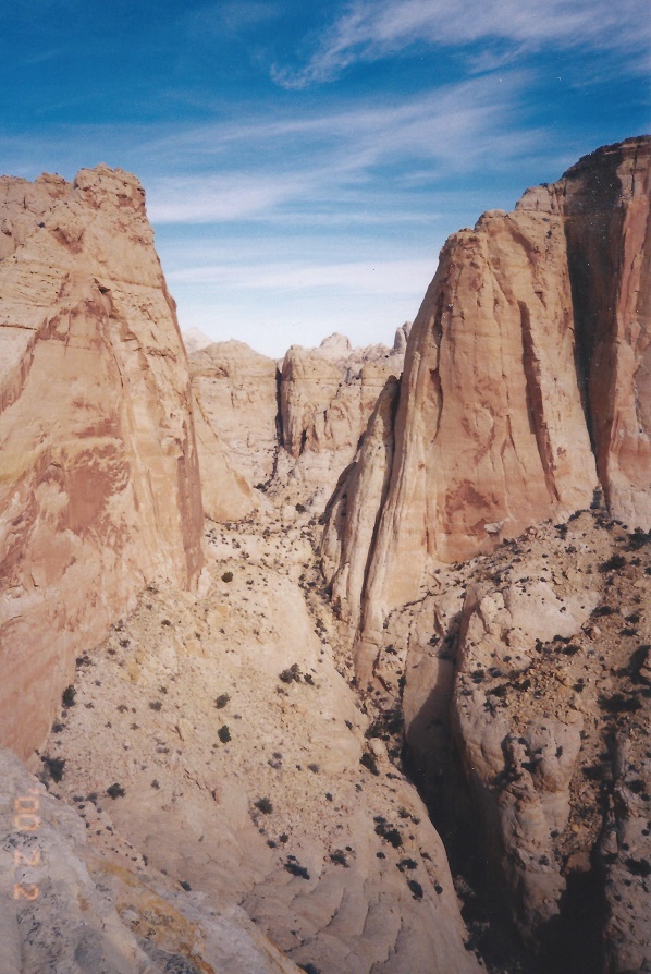
From the top of Navajo Dome.
Navajo Dome is a nice symmetrical pointed "Chocolate Chip" shaped dome plainly visible from Highway 24 just east of the Hickman Bridge Parking lot. The hike is relatively short but requires energy and scrambling to earn the nice views.
| TIME: | 4-5 hours. |
| ELEVATION GAIN: | 850 feet. |
| DIFFICULTY: | Moderate route finding. Difficult scrambling. |
| MAP: | Fruita |
| CIRCLE TRIP | No. |
| ACCESS: | From the Visitor Center drive two miles east on Utah highway 24 to the (H) Hickman Bridge parking area. |
The following historical sketch of Hickman Bridge was offered by Steve Allen. The Bridge was named for Joe Hickman, who was born in the area in 1887. He was a state legislator and taught at Wayne High School in Bicknell for many years. Hickman was a promoter of designating Capitol Reef as a National Monument. Hickman drowned when a sudden storm hit while-he was boat fishing on Fish Lake. The bridge was variously called Broad Arch, Fruita Natural Bridge, and Holt Natural Bridge. Leo Holt, an early settler, is said to have discovered the bridge. The Hickman bridge parking lot is in the Kayenta Formation though all the tan rock above the parking lot is part of the Navajo Sandstone.
From the parking lot take the trail 0.3 miles to the Overlook/Navajo Knobs trail junction. Go right toward the overlook. At that junction there are a plethora of black boulders on the near slopes. These were washed down the Fremont River from Boulder and Thousand Lake Mountains west of here during a time when glaciers were melting off those mountains and stream flows were significantly higher than they are today. Just a few minutes of hiking will take you far enough from the river channel that there will be no more black boulders. From the junction the trail climbs a little hill then goes down to and crosses a wash. On the far side there is a silver green leafed bush on the left and more just beyond on the right. These are Silverleaf Buffaloberry. Cross the wash and go another 150 feet or so.
(B) Leave the trail by turning to your right (north) and go gently up to the north (slightly east), crossing relatively smooth ground to the top of a bank looking down into a wash. Drop into the wash and go up stream. At the wash junction go right (east). If you get to a large Ponderosa Pine you have missed the junction. Go back down the wash and take the other fork.
Just a couple minutes above the junction climb out to your left to the ridge top. On the ridge turn left (south), walk a short distance, then (G) look over the huge Ponderosa Pine growing up out of the wash below.
From the Ponderosa vantage point go north to the Navajo Sandstone and climb up the nose of the ridge beside Navajo Dome wash. There is no way to stay on the west side of the ridge so when you can, move to the east side. At the top of the nose walk a semi-level bench for a couple yards then (J) angle right and go up the sparsely vegetated ramp for about 75 yards. From the end of the ramp, go slightly right again to the top of the ridge.
To the right (east) you will see an expanse of bed rock leading to a drainage. Go to that drainage and climb it until you reach the level of a bedrock bench on your left.
(C) Leave the drainage and walk the sloping bedrock bench to where it pinches out. (D) Just before it pinches out you can get up on to a ridge. Once on the ridge walk north up the ridge to a level where you can go northwest. Go down twenty-five vertical feet to the lower bench and follow it quite a ways to where it is covered by rubble. Turn left (and pretty much stay left) going all the way down into Navajo Dome wash (I). Once in Navajo Dome wash walk up the wash to a notch at the top and enjoy the view.
After the view return back down from the notch a short distance and follow a rock covered bedrock bench south. (E) The bench will turn into a rubble slope but keep going toward the dome. As you approach the mass of Navajo Dome you will see a tree dotted cut leading to a notch north west of the summit.
The drainage from that cut crosses a bedrock saddle in front of you. Cross that saddle staying on the rock and climb a couple (2) yards to a bedding plane (a natural smooth surface). Follow the bedding plane southeast a ways until you can easily climb up on the rock above it. Turn back west to the ridge looking into the tree dotted cut, then angle up and southeast, making your way to another bedding plane near the base of the vertical summit cliff.
From here, move east and south dropping some as you go.
Continue around the dome walking south, west and on around to north. From the far west side the summit can be obtained by doing some scrambling over small cliffs.
From the top of Navajo Dome.
 | ||
23June2017
|
Email: | |
