The 1950s uranium prospectors certainly had some beautiful country to check out. They covered all of this hike, and left their marks in places, but they could not destroy the beauty of the area. The high, steep walled Navajo Sandstone canyon easily traversed by this hike is one of many beautiful canyons along the west side of Halls Creek. The climb out of that canyon is steep in places but a scenic trek and the trip across Red Slide is definately different.
There is far more trail and old road walking on this hike than most but do not plan on easy going.
| TIME: | 8-11 hours |
| ELEVATION GAIN: | 2600 feet. |
| DIFFICULTY: | Easy route finding. Moderate scrambling. |
| MAPS: | Deer Point |
| GEOLOGY: | Significant! |
| PLANTS: | Wet and dry communities. |
| CIRCLE TRIP: | Yes. |
| ACCESS: | From the visitor Center drive 9.2 miles east on Utah Highway 24 to the signed Notom Road. Turn right (south) and drive 13.6 miles to the Sandy Ranch Junction. Bear right (south) and drive 19 miles to the Burr Trail Junction. Go straight (south) and drive 11 miles toward Bullfrog to a signed junction. Turn right (west) on pavement and drive 0.8 miles to a signed junction. Turn right (west) toward Halls Creek Overlook. (H) CAUTION If this road is wet do not attempt it even with 4-wheel drive. The road is a bit rocky in places and has lots of clay on hills. Park near the pavement if the ground is wet, else drive 2.6 miles to another signed junction. Turn right (west) and drive 0.3 miles (of bad, high clearance road) to Halls Creek Overlook. |
Before leaving the overlook notice the skyline to the west. A long ridge comes up from the south along the top of the fold. Then there is a gap. Next there is a short section of ridge followed by another gap. North of that is a ridge that ends at Deer Point. Later in this description there will be a reference to "Short Ridge" (R) which will be referring to the above mentioned "short section of ridge".
Start the hike by walking down the trail to the valley. At the main wash (Halls Creek) there is a foot path just across the wash that you can walk or, follow the wash downstream (left). Along the foot path there are a number of large grey, smokey, soft bushes that are Sand Sage. You soon pass the mouth of Brimhall canyon (A great place to explore) and cross the wash from that canyon. Heading south there is a hill of red-brown rock (Entrada) ahead. Go to the left (east) of that. Whether you follow the main wash or cut cross country, the goal is to go up the second major tributary wash ahead (C) that comes in from the right (west). It is 1.2 miles south of the end of the Halls Creek Overlook trail.
If you follow the main wash, the tributary wash you want tumbles in from the right about 100 yards before the main wash runs into a wall of rock and turns hard left. If you have been following the trail on the west side of Halls Creek wash, turn right where the trail crosses the main wash and go just a short distance down stream to that tributary.
From that wash junction, the first bush on the left has tiny three lobed leaves and is Apache Plume. There are many more of them along that left side and then on the right also. After the first Apache Plume (still on the left) there is a Cliff Rose.
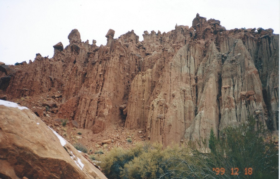
The first time the canyon narrows down you are passing through the Entrada Sandstone. The rock layer just west of that is the Carmel, but it is mostly buried and hidden by rock debris. The second time the canyon narrows you are entering the Navajo Sandstone portion of the canyon and the walls build very rapidly. The small trees on the right near the beginning of the Navajo are Single Leaf Ash.
Eventually there is a pour-over in the wash which is difficult to climb. Return back down the wash a few yards then climb out to the west (right when facing down stream). You will be amazed at what you find as you climb up that slope. Once on top, take the easy way back down to the wash and continue up canyon. You are walking through the Wingate Sandstone portion of the canyon.
You soon round a corner in the wash and get a more distant view ahead. Just upstream from that view the rock in the wash turns from red-brown to purple. The purple rock is the beginning of the Chinle Formation. It is in this formation that there is a rainbow of colors. Continue up the wash and notice a smooth brown ridge going up the slope ahead. Looking up you see that the smooth brown ridge turns grey quite a way up, then turns back to brown and there is a nice symmetrical cone of the brown rock with a small top capped with sandstone.
Walk toward the base of that smooth ridge. Just before the brown starts there will be a fairly narrow band of tan sandstone in the wash (U). That sandstone is what caused tremendous excitement in this part of Utah in the early 1950's. It is the uranium bearing Shinarump Sandstone. Notice how it forms a canyon rim as it sweeps up to the south and west. The floor of the plateau above is composed of Shinarump and was combed by those prospectors.
The route follows the top of that sandstone rim all the way up (1600 feet). Turn left (south) and go around the vertical wash bank to where the tan sandstone starts its climb. Once there turn south and climb close to the edge, walking the Shinarump bedrock when possible. The numerous rock cairns along that edge were made by the prospectors.
Early in the climb there will be two places where the rim will dip some. The large pedistal on the far side of the second one is almost scary when up close to it. At one other point it is necessary to climb above the sandstone then descend a bit but after that it is steadily up.
Eventually the slope lessens. When there is a good view to the west head toward the middle of the "short ridge" (previously noted) on the horizon. Keep watching the ground and find a faint old mine road (A) going north/south across your path. Turn left on that and follow it south. Please walk the left wheel track. Doing so will allow the road to become a trail.
This "road" is faint and forks in places. Some forks go nowhere, some are old reroutes that come right back, and some go off for miles. One or more forks go to a pass in the ridge to the west and on down into Moody Canyon. Another goes into the southwest corner of the Red Slide bowl. Meander generally south toward the Wingate cliff on the horizon. The road goes down (east) over Red Slide from close to the base of that slope.
There are two treacherous places on the road as you get to Red Slide. Be careful (or go around) on the first and definitely go around the second place where the old road has almost totally sluffed off the Chinle, leaving a hard sloped surface with loose rocks on it.
Once on Red Slide follow the road east to Halls Creek valley, then north to complete the circle.
 | ||
23June2017
|
Email: | |
