Cinnamon Rolls
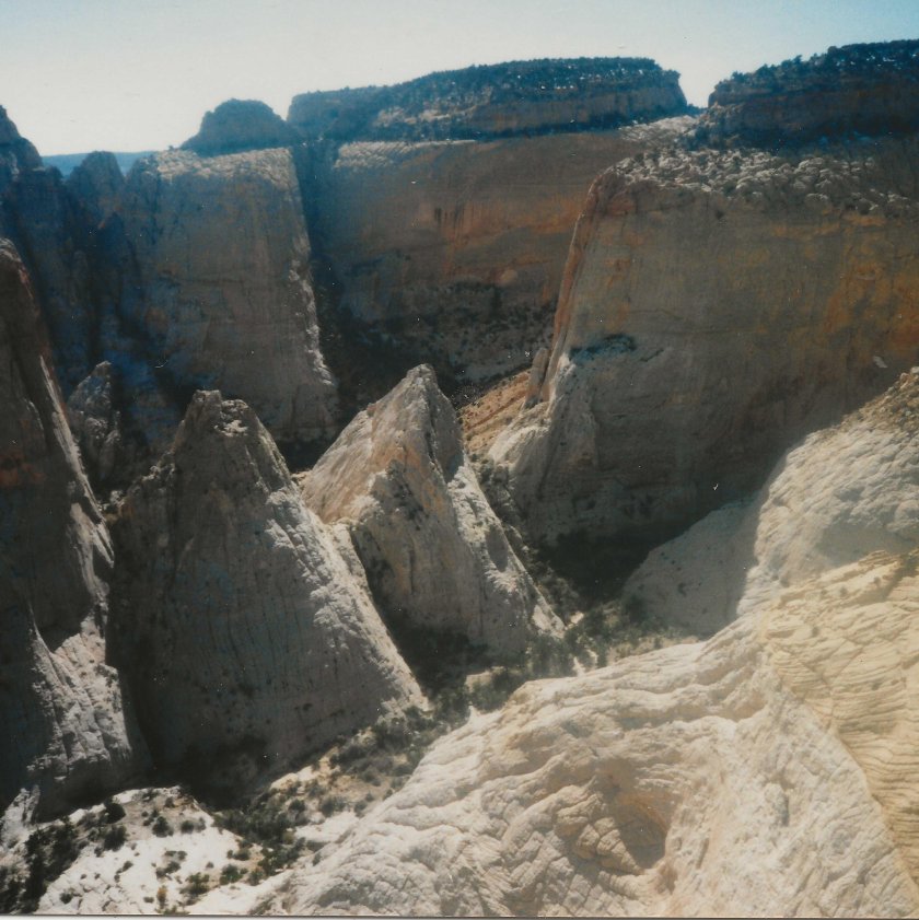
A nice walk into the Waterpocket Fold to a spectacular view point far above the visible canyon bottoms and still below but very close to the tops of the Cinnamon Rolls. There are pour-overs to skirt along the way, a fossil bed, and a nice inter-hike view.
| TIME: | 4-6 hours from the Park boundary. |
| ELEVATION GAIN: | 1400 Feet. |
| DIFFICULTY: | Moderate walking. Easy route finding. |
| MAPS: | Golden Throne, Fruita |
| CIRCLE TRIP | No.* |
| ACCESS: | From the Visitor Center drive east on Utah Highway 24 9.2 miles to the Notom road. Turn right (south) and drive 1.6 miles on the Notom road to a two-track road on the right. Turn right (south) and travel 0.5 miles. There are unofficial camp sites in the area and a track that turns off to the right (south) and into the nearest wash. (A) Park here unless you have a 4-wheel drive, high clearance vehicle. If you drive on, take the right fork, drop into the wash and head upstream. Go 0.1 miles to a "T" junction in the wash and go left (south). You can drive up the wash 1.1 miles to the Park boundary and park there. (B) |
Cinnamon Rolls
From the (unmarked) Park boundary, walk up the wash. There is a cliff on the left (southwest) and at the first break in that cliff, turn left (southwest) and walk up the rock ramp. In just a few yards you will come to the main wash again; you have thus cut off a 1\4 mile walk. Go up the main wash - or cut the corners as the cattle and game trails do - for 30 minutes to the first large (40 foot) pour-over. As you walk, the rocks around you are changing in color and texture. It is all Carmel Formation. Go around the pour-over to the right (north) In another 15 minutes you will come to a "T" junction in the wash.
At the "T" junction (C) go left (south). You can walk around the first pour-over (7') on the left (south). At the second pour-over you can go around to the right or left. The next pour-over (6') can be climbed. Just below the fourth pour-over, the shrubs on the right side of the wash are Apache Plume and the small trees below them are Single Leaf Ash. From where the fourth pour-over is visible, go back a very short distance and climb out of the wash to the right (north). It is a short climb (twenty vertical feet) to the first bench. Turn left (upstream) and go about 100 yards to where you will be able to see another pour-over in the wash. Go down so that you get into the wash immediately above that pour-over.
The next water hole/pour-over you obviously circumvent to the left. Go just high enough so that you can re-enter the wash by stepping onto the chock-stone boulder that forms the top of the pour-over. Walk up the side of the bedrock wash where there are a couple of rock basin water holes. One has a Tamarisk growing out to the downstream side suggesting there is water there most of the time. The next pour-over - about 30 minutes up from the "T" junction - is a bit larger and can be skirted to the left (south). Again, there is no need to go any higher than the top of the pour-over before re-entering the wash. A little ways above that, the wash splits. (E) Go right (north). You will have a significant stretch of rock to walk in the wash. After the end of the rock walk the canyon straightens out and you can see about 1/3 mile ahead. Walk a little farther to another split in the wash. Go straight and follow the wash until it totally peters out (nearly half a mile ahead). Along the way there is a steep section where the best route is to leave the wash by turning right (northwest), climb ten feet or so then angle left (west) up across the red brown layer. Stay to the right (north) of the drainage until almost to the top. Then get back in the wash for the last few feet to the top of the steep section.
As you approach the last little cliff before the top, look at the rocks around you. Many of them have small clam shell like fossils in them.
Once on top, the wash follows that fossil layer for a ways before the wash disappears. At that point, continue up slope bearing slightly to the right (north). You will come to a rim where you can look north and down into a deep canyon. When ready to move on, turn left (west) and follow the rim up to the next little cliff layer. Go immediately to the left (south) of the nose of the cliff and up to the top. Once on top go west until you can go no farther. Enjoy the view. (D)
Circle trip: When you are ready to move again, return to the place where you climbed up through the last little cliff. Looking east you can see a broad, shallow smooth bottomed valley a short distance in front of you. If you work your way down into that valley it will soon take you back to the route you came up.
It is possible to get into the canyon north of the overlook by returning to the rim where you had the first view to the north, then continuing north-east along the edge of the canyon until you drop into it. (See *) Once in, go down stream, left (east) around the big pour-over, and down to the "T" junction. It is also possible to get into the canyon to the south of the overlook by following that canyon edge down until you can get in. (See *) This would put you in an entirely different drainage than the one you came up, so, after walking downstream to the end of the canyon it would be necessary to go north over a ridge and back to the original wash.
* Entering a canyon in the middle of it can be dangerous since you do not know what obstacles are between you and your vehicle. There may be a pour-over you cannot go around.
 | ||
23June2017
|
Email: | |
