Floodwash canyon winds through the colorful Carmel Formation then enters a section of Navajo Sandstone that does not narrow as is typical, but stays quite open with minor drainages cutting the open area.
Ponderosa Pines and brilliant green leafed Manzanita speckle the sand dunes and vegetated pockets. In a sizable area, the Navajo Sandstone is quite colorful with shades of red, purple and yellow rather than the normal tan.
| TIME: | 3-5 hours. |
| ELEVATION GAIN: | 950 feet. |
| DIFFICULTY: | Easy route finding. Easy scrambling. |
| MAP: | Golden Throne |
| CIRCLE TRIP: | No. |
| ACCESS: | From the Visitor Center drive 9.2 miles east on Utah Highway 24 to the signed Notom Road. Turn right (south) on the Notom Road and go 6.1 miles. During that drive you pass Notom. At the top of the hill take the unsigned two-track road to the right and follow it west a total of 1.7 miles. (Dirt roads change over time but you want to get to Pleasant Creek.) |
After 0.8 miles go right at the first major junction. After an additional 0.2 miles you approach the edge of a bench. Two track roads go left and right along the top of the bench, but you take the rocky section straight ahead, then bear left. Go south for a ways, then at the next junction go either way since they go to the same place. There is another rocky section or two but go a total of 1.7 miles to the last bench above Pleasant Creek.
Park before the last hard left turn takes the road down into the creek. Stand at the beginning of that turn and look across the creek. There is a steep narrow cut in the creek bank on the opposite side. (A) Go down, cross the creek and walk up the bank on the south (left) side of the cut. Once on top, walk through the plants and rough ground, cross the irrigation ditch and get on the broad sandy area. The canyon was named (PN) Flood Wash Canyon by the local ranchers because water coming down this wash frequently washes out the irrigation ditch.
From here, follow the main wash up. As you start up there are a number of bushes with a Holly like leaf (including sharp points) The bush is Fremont Barberry. There are also some Dwarf Yucca. A bit farther up, the small deciduous trees are Single Leaf Ash and the common bush is Cliff Rose.
Thirty minutes up the wash, there is a fence crossing the wash. Water has taken its toll so the fence is now of little use. There is a red rock layer at about ground level at the fence. The walk, to this point, has been in the Carmel Formation and this is a very distinctive layer in the Carmel. It is very close to the bottom of the formation. Fifty yards up the wash from the fence you get into the light tan colored Navajo Formation and stay in it to the top.
Not far into the Navajo the wash makes a little bend to the left (southwest) and the canyon ahead is visible for quite a distance. It is an open canyon with lots of slickrock and water holes. Ponderosa Pine dominate down the center of the canyon, while Juniper and Pinyon Pine grow along the upper edges. Take your time and wander up. In some of the sandy areas you will find a green leathery leafed low shrub with red bark. This is Manzanita. The copper colored grass is called Copper Grass or Big Bluestem.
Where the canyon makes a major split, go straight up the left fork. As you round a slight right (west) bend in the canyon you will be able to see the top. Head for the broad nearly flat saddle on the sky line. (B)
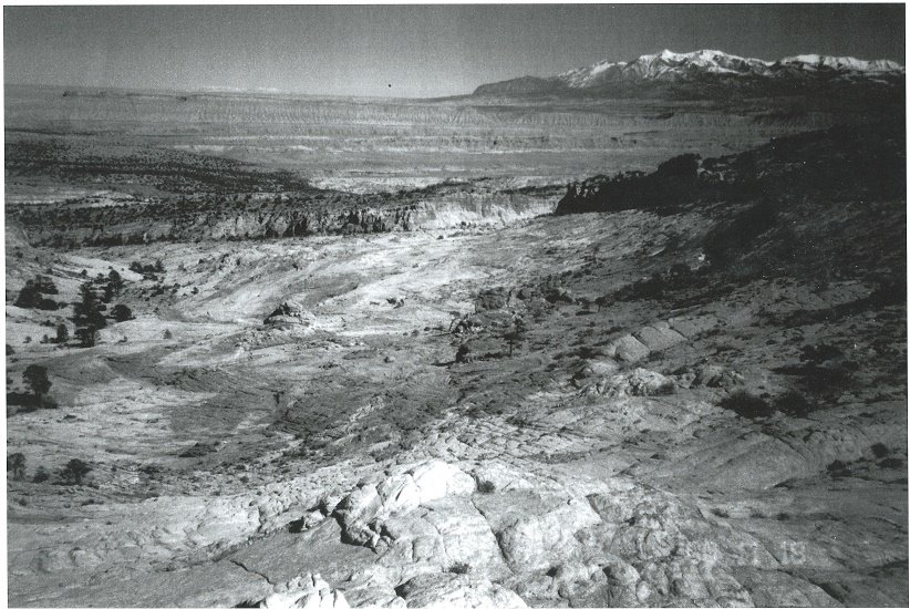
From the saddle there is a great view to the west. Below and a little south is Pleasant Creek. West of that is Miners Mountain, the reddish gentle slope, smooth topped hill. Miners Mountain is so named because copper was first found there in 1895 and uranium prospectors worked it over in the 1950s. Farther west on the sky line is Boulder Mountain. On the south sky line the red high point that slopes gently east is Buck Point. To the east, the distant mountains north of the Henrys are the La Sals, just east of Moab.
Should you wish to explore from the saddle, going north leaves endless possibilities and lots of country to play in. You can go all the way to Water Pocket Canyon and follow one of many canyons down off the fold. Some routes will offer more challenges than others so be prepared with plenty of food, water, energy and time.
Circle Trip: A small loop could be made by going north to the next drainage and descending that back to the route just walked.
 | ||
23June2017
|
Email: | |
