Reference: (page 1)
Capitol Reef National Park was established to set aside, among other things, a Geologic Monocline: a one sided fold in rocks. With little flat land, no forests of tall trees and generally sparse vegetation, the rocks are on display. The geology can be seen and discussed endlessly.
Enjoy the views. Since this is a hiker’s guide and not a geology text only the basic geology concepts visible here are covered in this quick section.
Sixty five million years ago the sedimentary rocks present today were already formed. The loose sand and dirt in the valleys was different. The land shapes were different. The Henry Mountains were still twenty million years away from being born, and the significant stream deposits along the Fremont River and other local streams were still waiting for the recent (8-10,000 years ago) glaciers to melt, but the rock layers were here.
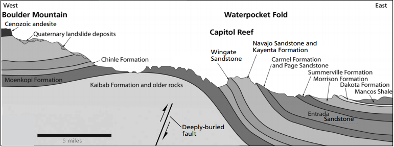
It is those rocks that were bent 65 million years ago that we see as the Waterpocket Fold. Something caused a significant bending on the surface. The fold was more "significant" than we casually observe today. To picture what has happened, try (or visualize) this: Put a stack of ten pieces of paper on a table. Now, lift one end and put a pencil under the paper. The paper that was flat now has a ridge in it. Next, put your fingers on the two sides of the paper and push them together slightly so that ridge gets larger. You have created a "compression ridge". The Waterpocket Fold is roughly a compression ridge. Now visualize five layers of one inch thick foam rubber on the floor; Lift one end and put a roll of carpet under it. Again, there is a ridge. Next, cut horizontally across the ridge taking off all but the bottom layer of rubber and a small amount of that bottom layer. You now have flat lying foam rubber, then sloping foam rubber, then a flat surface of layers of foam rubber. Put your fingers at the edge of the cut and "walk" your fingers across the cut. As your fingers progress they are crossing different layers of the rubber until they get to the bottom layer. Erosion has cut the layers of the Waterpocket Fold so now, as we walk along east/west we cross different layers of rock. Erosion, however, does not form a smooth surface. Harder rocks stick up, softer form valleys. The foam rubber ridge may have been 12 inches high. The Waterpocket Fold is 7,000 feet high. Almost all of it has been eroded off but we still can see and walk across the layers.
On the "2) Up Grand Wash" route described in this book a hiker walks through part of the White Rim sandstone, the oldest rock in the Park. If that hiker were to then walk Highway 24 east to the next town, Cainville, and look for the White Rim sandstone it could only be found by digging down 7,000 feet. (see diagram below)
Today, from valley bottom to ridge top the Waterpocket Fold is usually a climb of less than 1800 feet and nowhere is it more than 2800 feet.
Reference: (page 1)
 | ||
23June2017
|
Email: | |
