The hike goes to a great view point. Along the way there is some interesting country including slickrock ramps, grassy meadows, a large water hole and sandstone balls.
Near the end there is a twelve foot pitch of steep sandstone without a lot in the way of hand holds. Above that is 100 feet of exposed walking. The walking is reasonable but the exposure may get some people.
| TIME: | 6 - 9 hours. |
| ELEVATION GAIN: | 2,000 feet. |
| DIFFICULTY: | Easy route finding. Moderate scrambling with one exception noted above. |
| MAP: | Golden Throne |
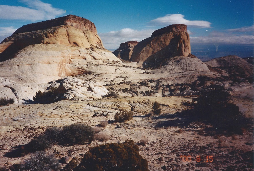
| GEOLOGY: | A rare and excellent view of the north end of the Waterpocket Fold from the top. |
| CIRCLE TRIP | No. Could easily be combined with a Fern's Nipple trip and end in Grand Wash if two vehicles are available. |
| ACCESS: | From the Visitor Center drive 10.3 miles south on the Scenic Drive to the east (far) end of the Capitol Gorge road. Walk the Golden Throne trail (A) to its end (B), then start this description. |
From the end of the Golden Throne trail walk east toward the base of the cliffs below Golden Throne then angle left (north). (S) A reasonably good foot path exists that goes north. The bench the path is on narrows to the north but is walkable. There is a large water hole (usually has water) thirty feet below the path just before it enters a wash. The water hole is accessible from the west. Once in the wash walk up stream. The copper colored grass in the wash is Copper Grass or Big Bluestem. There will be a straight stretch in the wash with some large Cottonwood trees on the right, then the wash winds a bit through some small Cottonwoods. Beyond, there will be a Manzanita shrub on the right that has bright green leaves and bright red bark.
Nearly 100 feet beyond the Manzanita there is the first major fork in the wash. What appears to be a tower of sandstone stands in between the two forks just before they meet. Just a few steps beyond that wash junction a third wash comes in from the left (west). (C) Walk west up the third wash, brush through two juniper trees and there will be a slickrock ramp to go up. That ramp lasts a long time and parallels a sandstone cliff on the right (north).
Where the main ramp goes left (west), follow it, then bear right (northwest) farther up and get back close to the cliff. The ramp eventually ends, but follow the wash up along the base of the cliff until there is a large Juniper tree leaning across the wash. At that point it is easiest to walk the right (north) bank of the wash for a ways. Continue up the wash to a low, wide break in the cliff. Turn right (north), go through the break and as you start through look at the view of Golden Throne. Climb through the break to the little pass, drop into the next wash, then turn left (west) and go up stream to where the wash ends in a grassy meadow. (Y) "George" is prominently ahead to the northeast but is most easily climbed from the northwest. Be careful in this fragile meadow area. Walk north through the broken meadow/woodland headed for the base of the cliff below George, then follow along that cliff line to the north. Below and west of the summit, or just beyond that, there is a small grove of Ponderosa Pine trees with one big tree near the sandstone wall. Continue north to the third (last) large Ponderosa. Just 150 feet beyond that tree there is a north/south trending gap that parallels the main rock wall. (X) Walk into that gap and up to the top of the pass. At the top turn right (east) and go up the rock, then continue climbing east though a slight bend to the left is OK. Go into the slickrock basin, cross it and continue east toward the high wall of sandstone. Washes parallel that wall, one from the south (" George" summit) and one from the north. Go left (north); up the wash, again, to the pass at the top. Turn right (east) and at the high point of dirt there is a Juniper tree close to the sandstone wall. Behind that tree the route is most difficult. (E) Climb the first twelve feet, then follow the groves (joints) in the rock going up and right (south). Only 100 feet or so beyond that the route to the top becomes easy and obvious. From the top (G), the view is fabulous. A rare aspect of the view is that it is fairly easy to see the birthplace of the Waterpocket Fold where it emerges from Thousand Lake Mountain.
Look north over the tan Navajo Sandstone and pick out the base of those tan cliffs as they go north. They go north, then bend slowly to the left, and disappear into the mountain. End of the Waterpocket Fold.
 | ||
23June2017
|
Email: | |
