 credit:NPS
Millers Canyon was called Millis canyon until the USGS got it wrong on their maps.
Though no part of Millers Canyon is within the boundaries of Capitol Reef National Park it is too neat a hike to leave out of this book. Most of the hiking is within the Park and most side trips would be in the Park.
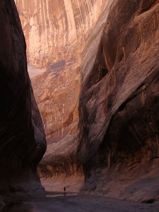
The Navajo Sandstone section of Millers winds through a beautiful canyon with a permanent stream, associated riparian flora and fauna, high smooth sculpted walls alternating with massive vertical cliffs, and two inviting abandoned meanders. (Abandoned stream channels)
This is the only trip in the book requiring one or more nights out. It could be done in three days by backpacking to the head of Halls Creek Narrows on day one. Day hiking to Millers Canyon and back on day two and packing out on day three. Because there is water available why not add a bit more freeze dried cardboard, rice or twinkies and stay longer. There is a LOT of great country to explore.
Overnight hikes are severely more complicated than day hikes and since this is the only one recommended, not all the necessary precautions, requirements, suggestions etc. are included here.
You must register with Capitol Reef National Park for any overnight stay in the Park. Phone 435-425-3791. Read and obey the rules and suggestions on the permit.
Camping spots abound in Halls Creek Valley. The Navajo slopes on the west side offer good places with slickrock for the campsite and sand for sleeping.
Water is always questionable in water holes but Halls Creek is a permanently flowing stream in and below Halls Creek-Narrows. The best water can be found in the tiny streams that flow out of each canyon and some defiles on the west side of the valley south of the Narrows. Flowing water in those canyons is preferable to that in Halls Creek itself.
| TIME: | Three days+ |
| ELEVATION GAIN: | 1500 feet (Return trip.) |
| DIFFICULTY: | Easy route finding. Lots of easy walking |
| MAPS: | Deer Point, Stevens Canyon North, Hall Mesa |
| GEOLOGY: | Great erosional features along the valley walk. |
| PLANTS: | A nice variety. |
| CIRCLE TRIP: | No. |
| ACCESS: | From the visitor Center drive 9.2 miles east on Utah Highway 24 to the signed Notom Road. Turn right (south) and drive 13.6 miles to the Sandy Ranch Junction. Bear right (south) and drive 19 miles to the Burr Trail Junction. Go straight (south) and drive 11 miles toward Bullfrog to a signed junction. Turn right (west) on pavement and drive 0.8 miles to a signed junction. Turn right (west) toward Halls Creek Overlook. CAUTION If this road is wet do not attempt it even with 4-wheel drive. The road is a bit rocky in places and has lots of clay on hills. Park near the pavement if the ground is wet, else drive 2.6 miles to another signed junction. Turn right (west) and drive 0.3 miles (of bad, high clearance road) to Halls Creek Overlook. |
| ADDITIONAL INFORMATION: | Four miles (each way) can be saved by using the Landing Strip route to Halls Creek. This shortcut significantly increases the required hiking ability and experience for the hike. |
| ADDITIONAL GEAR: | Consider creek walking footwear. |
Follow the trail from Halls Creek overlook (H) down to Halls Creek. It is well marked though usually not well maintained. Once at the bottom hike south down Halls Creek on the trail. Often it is soft and difficult walking but the wash is also soft and it winds more. Interesting side trips are everywhere along the entire route. Brimhall Bridge is the first of those but any canyon, defile or sandstone slope can be a treat.
One hour plus into the walk observe the north (close) side of Red Slide. An old dozer track goes up the slide from near the northeast corner and offers pretty good footing for a side trip into the slide basin.
Though we see no change, the pedistal population on red slide is a viable population with new ones being born, young ones growing, and old ones deteriorating and eventually dying as the base crumbles and the cap rock falls. The landslide set the stage, now wind and rain control the action.
Just below Red Slide on the right (west) side of the valley Fountain Tanks sit a few tens of feet above the valley floor and hold their water from storm to storm. The tanks are big and hold hundreds of gallons of water that can be used to drink or cool off as long as the water is treated for drinking and hauled off site (out of the drainage) to use for cooling or washing. Do not put anything (including yourself) in the water.
Two miles below Fountain Tanks Hopsage Canyon sneaks into and penetrates the fold. The name of the canyon comes from a "misplaced" plant community growing in the canyon which is typical of the Mojave desert. Great side trip.
Less than a mile farther down another canyon on the west is a fun walk into the world of Navajo Sandstone.
About two and a half miles below Hop Sage Canyon Halls Creek turns right (west) and slices through Halls Creek Narrows in an awe inspiring sashay. Water flows year round creating a riparian thread through thirsty sand dunes and exposed rock all encased in twisting, towering sandstone walls. The water is usually no more than four feet deep at the one or two deepest places and-there are no waterfalls to battle. Just an easy, breathtaking walk.
credit:NPS
At the foot of Halls Creek Narrows a Navajo Sandstone barrier continues downstream on the right (south) side for a couple hundred yards before ending at a gray shale Carmel Formation bank. The old road crossed at this point, went up on the bench and headed south. The Capitol Reef National Park boundary (sparsely marked) is one+ miles south. Follow the road scar (trail) until is slides down into the creek. From there on the best route, though rolling, is on the west bench along a braided trail that usually runs close to the edge of the sandstone slope. The creek is an option in proper foot gear but vegetation and quicksand can be a nuisance.
In Millers Canyon some of the ground surface and small items on it are covered with a white deposit. It is not as extensive in Millers as in some places but still it is there. The white is an accumulation of evaporite minerals that have accumulated as water evaporates. The white is a guarantee that the water is high in dissolved solids. Filters do not remove dissolved solids. Some digestive systems have a problem with this type of water. Anywhere below Halls Creek Narrows, each canyon and most small drainages have seeps in the sandstone and the water is low in dissolved solids. Load up with water before entering Millers Canyon.
One mile or so south of the Park boundary notice the long ridge ahead that extends from the right (west) side of the valley southeast to the far side. That is an alluvial ridge built by Millers Creek. Though Millers Creek joins Halls Creek at the far (east) end of that ridge there is no need to walk down there and then back up Millers Creek.
Closely watch the approach to that ridge. The trail goes through a shallow dip and across a wash. The wash separates the alluvial ridge from normal weathered bedrock and cover. Follow the trail 100 feet or so up from the little wash then turn right and climb to the top of the ridge. Follow the ridge west all the way to the end of the dirt, then go down to the creek (E) and move up the canyon.
The sediment of Millers Creek is a good consistency to hold the tracks of anything that travels the area so there is a great story to be read along the way.
At normal flows the canyon can be walked in hiking boots without getting them wet. A narrow portion of the canyon can easily be walked but can also be skirted on an old dozer track on the left side of the creek.
After the canyon opens at the far end of the Navajo Formation the right (north) fork of the creek is easy to walk for quite a way due in part to another dozer track that circumvents a narrow section on the right.
These dozer tracks are a result of the search for Uranium in the 1950s. The Chinle Formation, extensive in the floor of the canyon, was the source of most of the ore.
The return trip offers an option of going back up through Halls Creek Narrows or following the trail over Hall Divide.
 | ||
23June2017
|
Email: | |
